Great Allegheny Passage
The Great Allegheny Passage and the Chesapeake & Ohio Canal are bucket list bike trips. These two trails form a seamless 335 mile route from Pittsburgh to D.C. This is Part 1 of the adventure, beginning in Pittsburgh, crossing over the Alleghenies, and descending into Western Maryland. The GAP is an action-packed trail of varied terrain, full of literal highs and lows and a world of unforgettable sights.

Ride Details
163 miles
4 day ride
Depart: Amtrak Pennsylvanian
Penn Station >> Pittsburgh
Return: Amtrak Capitol Limited + Northeast Regional
Cumberland >> Penn Station
Mostly fine crushed stone
Night 1: Stay in West Newton
Night 2: Stay in Ohiopyle
Night 3: Stay in Meyersdale
Night 4: Stay in Cumberland
NOTE: This trip is best done combined with the Chesapeake & Ohio Canal to make a full week-long bike journey from Pittsburgh to D.C.
This trip is a big one and there’s a lot to take in, so bear with me—and also don’t rely entirely on me. There are a wealth of good planning resources out there, including the dedicated website for the Great Allegheny Passage (aka GAP) as well as this site. Here are a few pro tips to call out up front:
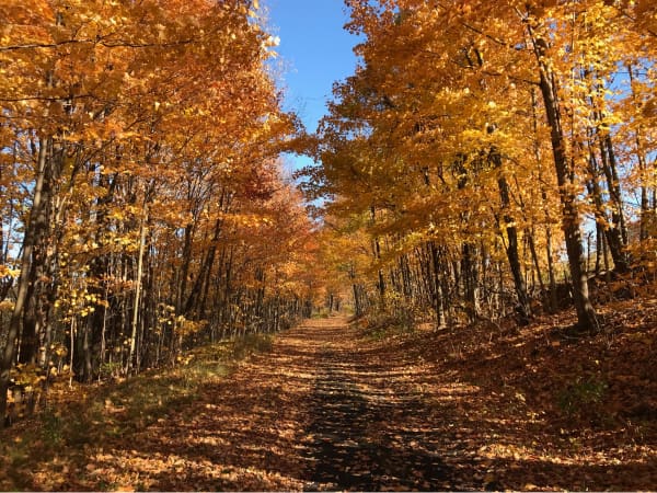
- When to go? Spring, summer, and fall are all fair game. I rode toward the end of the biking season in early November and loved it. I felt like I had the trail to myself and the frosty mornings mixed with autumn foliage were especially serene.
- How to get there? Amtrak has become surprisingly easy for schlepping bikes across the country with carry-on bike service on many trains now. The Pennsylvanian goes direct from NYC to Pittsburgh. If you can, splurge on a private room to make the journey cushier. Same deal on the return via the Capitol Limited from Cumberland to DC, then changing to the Northeast Regional to get back home. Just budget a day on both ends for transit.
- Where to stop? There are so many ways to slice the 150 miles of the GAP, depending on whether you’re lodging or camping, what towns you want to see, and how many miles you want to ride per day. What follows below is the route I took. Feel free to do it differently, but I would highly, highly recommend that you crash one night in Ohiopyle no matter what. That area is a real highlight.
Day 1: Pittsburgh >> West Newton
Stay Downtown. The train from NYC will arrive at night. Downtown is close to the train station and where you’ll start in the morning. I chose The Industrialist, which felt like the right vibe for this leg of the trip.
Start with a little Andy. If your schedule permits, begin your day with a visit to The Andy Warhol Museum, one of Pittsburgh’s premier cultural institutions. If you’re riding later in the season and short on daylight hours, you can at least bike over the Andy Warhol Bridge. Roll into Allegheny Park on the other side for an epic bike selfie against the Pittsburgh skyline.
Worship the bike gods at Bicycle Heaven. I struggle to find the words to describe this place. The “Temple to Cycling” feels close. Click through the photos in the link to see for yourself. Allegedly the world’s largest bike shop and museum, I can think of no grander start to your trip than this place. Getting there from Downtown also provides a nice little bike tour of the waterfront via the Three Rivers Heritage Trail. Fans of the King can snap a bike selfie in front of Graceland Automotive on the way.
Really start at Point State Park. As the western-most point of the GAP, this is where the trail officially begins. A nice medallion is embedded in the pathway to mark it.
Get breakfast at Waffles, INCaffeinated. A wonderful place to fuel up before hitting the road. I got the Country Mile breakfast sandwich, highly recommended. The waiter asked me if I wanted potatoes or chips on the side. Before I could respond, he answered, “I’m gonna get you the potatoes because chips are gross and not good for you.” I swear they were the best roast potatoes I’ve ever had. I left him a good tip.
First it gets industrial… The initial segment of the trail running from Pittsburgh’s South Side to McKeesport is aptly named “Steel Valley” and characterized by monuments of industrial decay. Derelicte from Zoolander comes to mind. Onward!
…and then it gets nice. After McKeesport, the trail hugs the Youghiogheny River through small towns and under a dense tree canopy for the rest of the way. It’s all very pleasant.
Don’t miss the Red Waterfall. You’ll pass it on the way, and it looks much nicer than it smells. The color is the result of acidic runoff from a coal mine dug over 120 years ago that still plagues the water supply. I met a guy named Jack there. He’s 70-something, a lifelong nature photographer and former boxer. Loves biking rail trails and snapping shots of waterfalls. He’s also a rabid anti-vaxxer. “The last shot I got was in the Marine Corps in 1969. Never again!” All this during peak COVID. Onward again!
Welcome to West Newton. This place feels like the definition of a one-horse town. You’ll pass a cool old train station and rail car on the way in before hitting Main Street, really the only street in town. There are eateries right on the trail for the standard fare, including The Trailside and Fox’s Pizza Den. I crossed the river for a pint and a quesadilla at Bloom Brew, which is somewhat hidden in the back of the volunteer fire station warehouse.
Stay at Bright Morning Bed and Breakfast. Nice, simple, and clean with a lockable bike shed out front. The owner Rob and his wife are lovely. Should you hear an air raid siren at 2am, fear not, it’s the fire department not a foreign invasion. Apparently, they wake up the town quite regularly.
Day 2: West Newton >> Ohiopyle
Get breakfast at Bright Morning. Candidly, it’s nothing to write home about but it does the trick and they serve early. I was only truly upset about the frozen bagels, which I recognize is more my problem as a New Yorker than their problem as a BnB in Western Pennsylvania.
Enjoy the ride. The trail is leafy and leisurely from the get go. Stop in “historic” Dawson to see the Cochran House. I don’t know what is historic about Dawson or the Cochran House, but it does make for a nice bike selfie. From there, pedal lazily to the view of the river to your left, the occasional rock walls to your right, and the forest canopy overhead.
Watch out for rattlers. No, really. I had read somewhere that in the warmer months 5 foot rattlesnakes will sunbake horizontally across the trail. Biking in late autumn, I didn’t pay it any mind until a morning stroller called out, “Any snakes up that way?” So keep an eye on the trail too and not just the views around you.
Eat in Connellsville. The stained glass arch over the trail announces your arrival into town. Kickstand Kitchen is a good sandwich spot. There’s a cool railroad mural on this building a block away, good spot for a bike selfie.
Gear down for the incline. While Days 1, 2, and 3 of this trip are all technically uphill, the grade is so gradual you rarely feel it, except when you do. This ride from Connesville to Ohiopyle was when I started to feel it. Part of the burden for me was that this stretch of trail had been recently resurfaced with crushed limestone, making for a sandy slog. Powder is a blessing on skis and a plague on a bike. Push on, uphill and hopefully through less sand than I had. And then you’ll see them… a teenage jogger, a retired couple, a family of four. Pedestrians on long distance bike trails are like the sea birds alerting sailors to the imminence of land. Your destination is near!
Welcome to Ohiopyle. Without warning, Ohiopyle erupts out of the canopy with a 200 yard trestle bridge flying over the Youghiogheny, followed by the town’s namesake waterfalls. It is quite the arrival! Continue on for the grand finale of Cucumber Falls, a stunningly beautiful waterfall that, unfortunately, is up a giant hill. Cap it off with a bike selfie at the Ohiopyle Falls Observation Deck and a burger and beer at Falls City Pub.
Stay at Falls Market Restaurant & Inn. Just like Brightwood, it’s nice, simple, and clean with a safe space to lock your bike.
Day 3: Ohiopyle >> Meyersdale
Get breakfast at Falls Market Restaurant & Inn. Specifically, get the breakfast sandwich.
Visit Fallingwater. I find many “must see” sights hardly live up to the hype. Fallingwater’s reputation, by contrast, is definitely well earned. The house, the setting, everything is exceptionally beautiful and unique. Start your day here and sign up for the first tour of the day to beat the crowds. When I went, the house tour was sold out, so I was only able to do a self-guided exterior tour. The silver lining was that I could roam the grounds before the tour groups started and had the entire place to myself for close to an hour. Wilderness Voyageurs Rafting & Bike Tours runs shuttles to the house (you don’t want to bike there) and is close to Falls Market.
Watch out for Bigfoot. On the shuttle back to Ohiopyle, the driver asked “You got any Bigfoot in Maine [where I was living then]?” I thought I hadn’t heard him correctly. Sure enough I did when he added, “Ohiopyle State Park is #1 for Bigfoot sightings.” Good to know. Some other fun facts I learned from him: 1) Ohiopyle is one of only two towns in America to be located within a state park; 2) the Youghiogheny River is the best place to go kayaking east of the Mississippi; and 3) Youghiogheny is pronounced yuck-eh-genee. Who knew?!
Stop in Confluence? Confluence, aka “Turkeyfoot”, sits at the—you guessed it—confluence of three separate waterways that from above—you guessed it again!—resembles a turkey foot. A lovely fall photo of Confluence adorns the cover of my trail map and the town is generally well regarded as a “must see” destination in most GAP guides. Arriving in late autumn after Confluence had pretty much closed for the season, I would call this one a pass. Maybe you’ll have better luck at a different time of year.
Ride prepared. The trail between Confluence and Rockwood is very off the grid. No cell service, electric lines, roads, houses, and certainly no towns. Just the river to your left, forest to your right, and the path straight ahead, all for miles on end. The Pinkerton High Bridge, Low Bridge, and Tunnel are pretty much the only signs of civilization. It’s all very tranquil. That said, be sure to carry everything you need—water, snacks, spare tubes, bike tools, etc—just in case anything goes wrong.
Eat in Rockwood. Your best bet is the Rockwood Mill Shoppes & Opera House, not because the food is particularly good but because it’s just about the only lunch option around. It’s also a cool building with a funky antiques shop behind the restaurant.
Take in the Salisbury Viaduct. And let it take your breath away. It’s just… wow. Biking along this nearly 2,000 foot long bridge makes the world beneath you look like a giant toy train landscape.
Welcome to Meyersdale. The old train station marks your entrance. Look for the bright red Western Maryland caboose too, good spot for a bike selfie. Meyersdale, you may be surprised to learn, is “Maple City” and home to the Pennsylvania Maple Festival celebrating all the syrupy goodness. Grab dinner at White House Restaurant for the local equivalent of fine dining or Donges Drive-In and Motel for cheap eats.
Stay at Yoder's Guest House. Another nice little BnB that is well set up for this type of bike trip.
Day 4: Meyersdale >> Cumberland
Get breakfast at Yoder's Guest House. Starts early and does the trick. If memory serves me right, this was the best morning eats I had since the Waffles place in Pittsburgh.
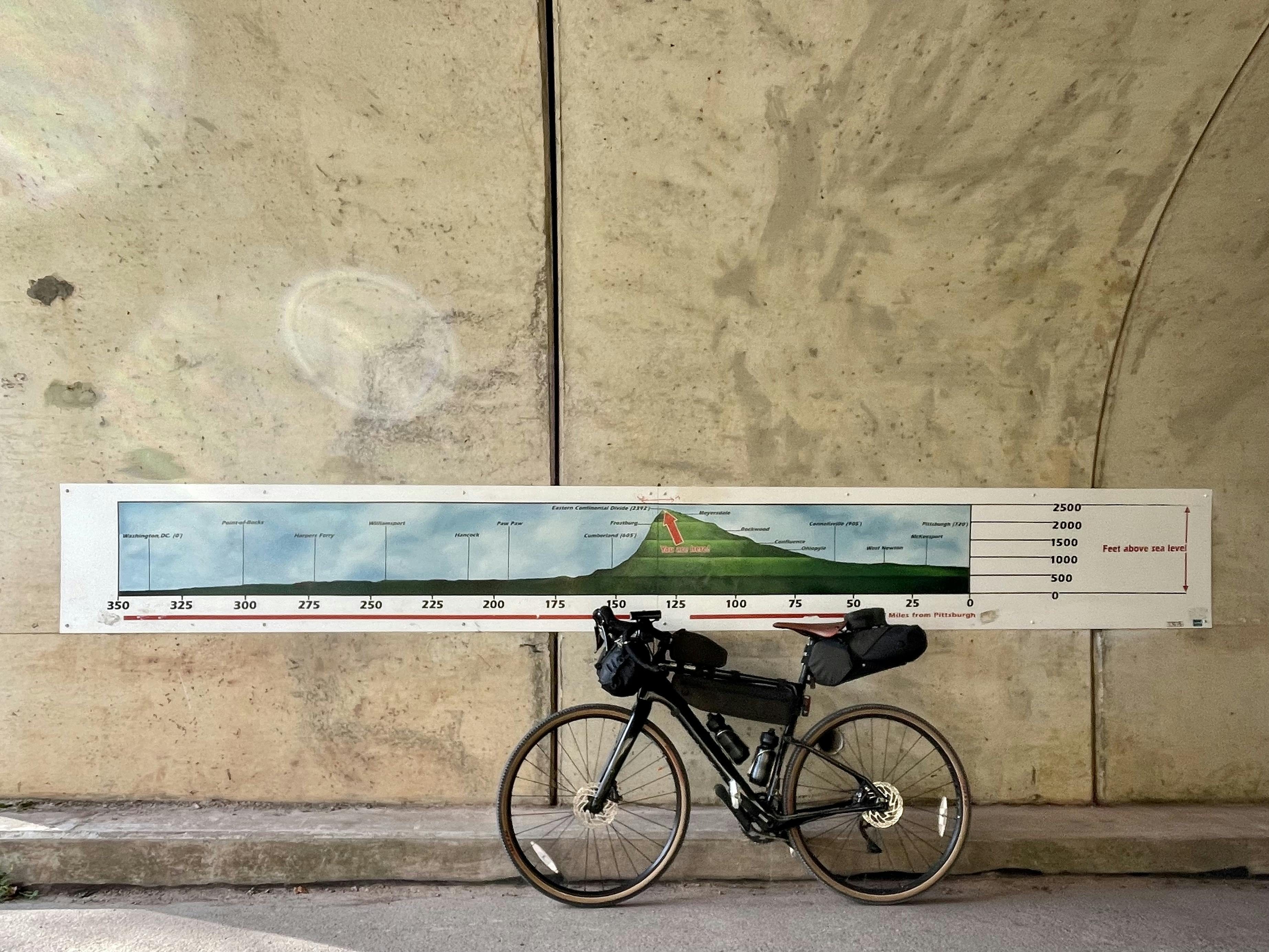
See the sights. The road out of Meyersdale is among the more scenic of the trip, with multiple sights falling one after another on the trail. First you’ll pass the Bollman Bridge and Keystone Viaduct before arriving at the Eastern Continental Divide. After three full days of pedaling uphill, take a moment to appreciate that you’ve just crossed a mountain range by bike. Maybe take a bike selfie too (see the lead photo for this trip above).
Enjoy the descent. The trail from here on out is a magical descent all the way down to Cumberland—over 2,000 feet in a little over 20 miles. Send it!
Fly through Big Savage Tunnel. It’s the longest bike tunnel in the world at 3,300 feet. You pedal and pedal away, but the light at the end of the tunnel never grows nearer. It’s a weird sensation. Be sure to have your bike light on because the tunnel is pitch black, with the exception of a literal (electric) light at the end of the tunnel on a motion sensor—it seems awfully superfluous by the time you trigger it.
Savor the view at Big Savage Vista. Exiting Big Savage Tunnel presents the kind of pièce de résistance you would expect for crossing a mountain range under your own locomotion. A breathtaking view stretches out for miles to the east. Take it in.
Cross the Mason-Dixon Line. The border between Pennsylvania and Maryland arrives in short order after the vista. What I had always thought was a creation of the Civil War, I learned, was actually a vestige of a property dispute between two feuding colonial British families prior to the Revolution. It also makes for a nice bike selfie spot.
Eat in Frostburg. The town is up a giant hill, I’m sorry. At least there is a dedicated switchback bike path to get you up it. The Train Depot is a nice reward. Get lunch at the Clatter Cafe. For usual diner eats, Princess Restaurant is the place to go.
More downhill. The remainder of the descent from Frostberg to Cumberland runs parallel to the tracks of the Western Maryland Scenic Railroad, the only continuing passenger service on this right of way. It’s a leafy, winding road out of the mountains and very fun.
Welcome to Cumberland. And congrats on completing the GAP! At the GAP/C&O Junction you’ll find a similar medallion embedded in the path to the one at the start in Pittsburgh, officially marking the end of the trail. While you’re in the neighborhood, check out the old train station at Canal Place, “The Cumberland” canal boat at Canal Place Stage, and George Washington's Headquarters, all good spots for bike selfies. Eat at Ristorante Ottaviani for pasta or Baltimore Street Grill for bar grub.
Stay at Fairfield Inn & Suites by Marriott Cumberland. It’s exactly what you think it is and conveniently located right on the trail. I stayed at a local BnB that was lousy and would have much preferred the predictable corporate comfort of the Marriott.
Go home or keep going? From Cumberland, you’ll either hop Amtrak back to NYC or hop back in the saddle and keep going another 3-4 days along the Chesapeake & Ohio Canal to DC. You decide. Either way, get breakfast at Cafe Mark before you move on.


